Which states were free and which states had slavery?
How many slaves were there? How many black people were free? Which states did they live in?
How were the states and cities populated when the Civil War began?
Sometimes when learning about the Civil War it’s good to know the geography of the free and slave states, and how the free and slave states were populated. Provided here for reference is a map that shows the free and slave states, listings of the free, slave, and border states, tables of state and territory populations, a table of the total populations of the states and territories, and a table of the 10 largest cities in the United States in 1860.
In the times before and during the Civil War much of the United States was made up of farmland, unsettled territories, and lightly populated areas. Most people lived on farms or in small towns, but in contrast, there were cities like New York, Philadelphia, Boston, and New Orleans which were bustling with people, business, factories, and activity. The South had fewer people than the North, and the North had more enterprise than the South. The South was more rural with farms and plantations, and while the North had its farmers and rural places too, it had more cities. The division of slavery, the “peculiar institution,” would split the union of the states and bring on a Civil War that would end the lives of hundreds of thousands. A Civil War that would forever change the lives of the people and the landscape of the North and the South.
1857 General Map Of The United States Showing Free States, Slave States, And Territories
Click/right click on map for larger image.
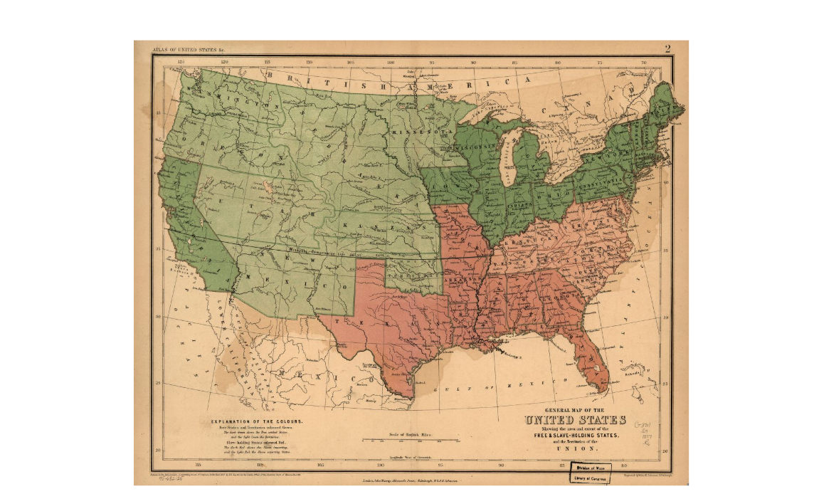
1857 General Map of the United-States
Map Color Key
- Free states and territories colored green.
- Dark green shows the free states.
- Light green shows the territories.
- Slave-holding states colored red.
- Slave importing states colored dark red.
- Slave exporting states colored light red.
- Boundary of the seceding states colored light gray.
Free States 1857
- California
- Connecticit
- Illinois
- Indiana
- Iowa
- Maine
- Massachusetts
- Michigan
- New Hampshire
- New York
- New Jersey
- Ohio
- Pennsylvania
- Rhode Island
- Vermont
- Wisconsin
Slave States 1857
- Alabama
- Arkansas
- Delaware
- Florida
- Georgia
- Kentucky
- Louisiana
- Maryland
- Mississippi
- Missouri
- North Carolina
- South Carolina
- Tennessee
- Texas
- Virginia
Learn Civil War History Podcast Episode Seven: Freedman Jourdon Anderson Writes A Letter To His Old Master
Spotify
Civil War Free States 1861-1865
- California
- Connecticut
- Illinois
- Indiana
- Iowa
- Kansas
- Maine
- Massachusetts
- Michigan
- Minnesota
- Nevada
- New Hampshire
- New Jersey
- New York
- Ohio
- Oregon
- Pennsylvania
- Rhode Island
- Vermont
- West Virginia (Became a state in 1863.)
- Wisconsin
Civil War Slave States 1861-1865
- Alabama
- Arkansas
- Florida
- Georgia
- Louisiana
- Mississippi
- North Carolina
- South Carolina
- Tennessee
- Texas
- Virginia
 Does reading about Civil War history from long and dry academic-like books bog you down and cause you to lose interest? Would you like to read interesting stories based on facts of the Civil War, stories that inform you and move along with the war’s history? Does having to read from cover to cover tire you and cause you to drag through a history book? Would you prefer the freedom to skip around in a book and learn story-by-story about the Civil War? If you answered “yes” to any of these questions, then the factual stories in 125 Civil War Stories and Facts will help you learn Civil War history. The stories are informative and entertaining and it’s a fun way to learn about the Civil War. Do books like Civil War Trivia and Fact Book by Webb Garrison or The Civil War: Strange & Fascinating Facts by Burke Davis interest you? Then you will find 125 Civil War Stories and Facts follows in their tradition of providing the reader with rich and interesting information about the Civil War. Available as a Kindle device e-book or as a paperback. Get 125 Civil War Stories and Facts now!
Civil War Border States
These are salve states that remained in the Union.
- Delaware
- Kentucky
- Maryland
- Missouri
United States Territories 1861
- Washington Territory
- Dakota Territory
- Nebraska Territory
- Colorado Territory
- Utah Territory
- Nevada Territory (Became a state in 1864.)
- New Mexico Territory
- Indian Territory
State Populations From 1860 Census
[table id=1-1860-State-Population /]
Notes:
(a) – does not include 294,500 Indians who kept their tribal character
(b) – 34,933 Asians included
(c) – Indentured servants
Data source: The Library of Congress Civil War Desk Reference
Territory Populations From 1860 Census
[table id=2 /]
Notes:
(a) – does not include 294,500 Indians who kept their tribal character
(b) – Populations included: Georgetown (8,733), Washington City (61,122), rest of the District (5,225).
Data source: The Library of Congress Civil War Desk Reference
Population Totals States And Territories Combined
[table id=3 /]
Notes:
(a) – does not include 294,500 Indians who kept their tribal character
Data source: The Library of Congress Civil War Desk Reference
The 10 Largest Cities Of The United States In 1860
[table id=4 /]
Notes:
Data source: The Library of Congress Civil War Desk Reference
Learn Civil War History Podcasts
[wp-rss-aggregator]
 My book 501 Civil War Quotes and Notes features quotes made before, during, and after the Civil War. Each quote has an informative note to explain the circumstances and background of the quote. Learn Civil War history from the spoken words and writings of the military commanders, political leaders, the Billy Yanks and Johnny Rebs who fought in the battles, the abolitionists who strove for the freedom of the slaves, the descriptions of battles, and the citizens who suffered at home. Their voices tell us the who, what, where, when, and why of the Civil War. Available as a Kindle device e-book or as a paperback. Get 501 Civil War Quotes and Notes now!
Related Posts:
- The Confederate States of America
- The United States of America
- Slavery
- Jefferson Davis And The Confederacy
- 1850 Fugitive Slave Law
- Thirteenth Amendment Abolishes Slavery

on your list of free states, where is Oregon and Minnesota?
This is a list of free and slave states from the shown 1857 map.
Oregon was admitted to the Union on February 14, 1859, and it was a free state.
Minnesota joined the Union on May 11, 1858, as a free state.
Oregon and Minnesota are shown in light green as territories on this 1857 map.
I have added “1857” in a few places to stress the year of the map.
MAKE A citation
I state in the post:
– Data source: The Library of Congress Civil War Desk Reference
– 1860 Census
What about Arizona? It is not mentioned.
Arizona was within a territory, its land is in the light green area shown on the map. Arizona became a state on February 14, 1912.
Thank you. Excellent coverage. I never hear of Mr. Jourdan’s story. I’m happy he and his wife used wisdom to remind his former slave owner of how he exploited them, owed them money, and their service is valable and comes with a cost. And how me and did’t go back putting he and his family in danger. I’m glad the slave owner was forced to sell at a loss. That was for all the years of brutally and forced free labor & many years of wealth and comfort he & ancestors enjoyed. Keep up the good reporting